Skyline Trail, Jasper

Skyline is a popular backcountry hike that has only six small campsites along the trail, which meant that we had to be ready to book them nearly eight months in advance in January when Parks Canada opened reservations!

After doing some research last fall, we decided to hike in the direction most commonly recommended: south (Maligne Lake) to north (Signal Mountain). Plan A was to take three days to hike so we could fit it into the long weekend while not feeling rushed. But the reservations filled up very quickly! Within minutes of opening, our first choice of campsite combinations was unavailable, forcing us to go with plan B and take four days to hike...and I'm SO glad we did. My retrospective relief isn't because of the shorter distances we hiked each day but because of the timing of the weather; wind and rain caught us on one of the easier hiking days but clear, blue skies and sunshine came out for the most difficult leg of the hike!

Because more than half of the trail is above the tree line, Skyline can only be hiked during the summer, usually from mid-July to beginning of October. Various blog posts and reviews of this hike all warned us about the same three things: swarms of mosquitoes at campsites (ew), waking up to snow (in the summer!), and very cold nights (boo). All of this plus the fact that campfires aren't allowed made me a bit nervous that everyone I had asked to come with me would end up hating me for bringing them along! Thankfully, we barely saw any mosquitoes (no fashionable bug-nets needed for us!), patches of snow were only seen atop mountain peaks, and I was well prepared for the cold.

Day 1: Snowbowl Campsite
We left Edmonton at 4:30AM on Saturday to make sure we didn't miss the Maligne Valley Hikers Express Shuttle at 9:00AM. We got to Jasper with time to spare so we picked up waterproof trail maps from the visitor centre before heading to the Signal Mountain Trailhead. The parking lot was tiny so cars were spilling out of the entrance and onto the roadside. During the hour shuttle ride, we could feel the it climb uphill and were glad it was doing the work instead of us! Our first night was booked for Snowbowl, the third campsite in from the trailhead, which was about 12 km in and 400m up from the Maligne Lake Trailhead.

We had perfect hiking weather this day: sunny, with a cool breeze. We stopped to have lunch on the boulders along Evelyn Creek, just before the bridge.


I was often near the back of the group, if not the caboose, because of my almost uncontrollable need to examine every plant that's interesting to me (which is most)!


Another 3.5km and we were at Little Shovel Campground where Z took a cat nap and the rest of us took a snack/washroom break. I found a comfy crook of a tree branch to perch on and sing Sound of Music songs from... (:


The majority of the 12 km was a slow climb (a cheerful one for me because Climb Every Mountain was playing on repeat in my head ♫); the rocky dirt path zig-zagged through trees, took us over countless tree roots, and brought us to some spectacular views that motivated us to keep going!


At around the 10 km mark, we descended into "the bowl": a quiet, meadow valley with streams weaving through it, dotted with purple flowers and silver-leafed plants.


Of all the plants I saw, these wispy-haired fluff balls were by far my favourite! The fuzzy tendrils looked like ostrich feather hairs. Don't they look wise and graceful?

...fooord every stream ♫ Can't you just hear the Sound of Music soundtrack? This trip was a great warm-up for watching the Sound of Music musical a couple weeks later!

By the time we reached the Snowbowl campsite, I was ready to take off my hiking boots! We set up our tents, switched to flip flops, and enjoyed our dinner with mountains all around us. All the campgrounds were laid out similarly: an eating area with a a few picnic tables, several bear lockers and bear poles nearby, and tent pads scattered throughout the woods at least 50m away (in case hungry bears happen to come check out the food). Unfortunately, the stream running (well, trickling) through the campsite was very shallow (about 1-2 inches deep!) so we filtered the water and started boiling it when, thankfully, other hikers told us that they had all been drinking it just filtered with no issues. Because the water was so clear, I decided to forego the boiling and save us some time and fuel. I'm happy to report that no one got sick throughout out entire hike!

If you've never been backcountry camping, you may wonder what one eats on this kind of trip. It really comes down to what you're willing to carry in and how much you dislike dehydrated foods. Some people don't mind carrying pasta sauces (I've seen glass jars of it in the food lockers :O) or even an entire HAM! We met a man on the West Coast Trail who had brought ham and potatoes to "eat like a king", which also meant his pack weighed around 80lbs! We typically keep it simple and bring instant oatmeal and coffee for breakfast, canned tuna, crackers, nuts, and granola bars for lunch and snacks, and prepared, dehydrated meals for dinner. The best part of the dehydrated food pouches is how easy they are: no need to cook and no dishes! You boil water, throw a couple cups in, seal the pouch, and 10-20 minutes later (depends on which meal you're rehydrating), voila!

As we made our way back to the tents after filtering water and filling our water bladders/bottles for the next day, brushing teeth, and using the mountain-view washrooms, it started spitting. The rain started pouring as I settled into my sleeping bag and it lulled me to a glorious 12 hour sleep!

Day 2: Curator Campsite
The next day, we woke up to a blanket of grey clouds looming overhead. Remembering that we had seen rain for the forecast for that day, we all packed our raincoats, rain pants, gaiters, and waterproof pack covers into easily accessible places before starting our hike at around 9:45AM.

The beginning of the day was pleasant to hike: rolling hills, several streams and rivers to hop across on rocks, and lots of greenery and more of my fuzzy friends.


About three hours in, it started sprinkling and on went our bright, waterproof pack covers and raincoats. Spirits were still high...until we started the uphill grind to get out of the Snowbowl.

The rain steadied and the wind started to pick up around us as we continued our climb out of the bowl, over Little Shovel Pass. As we kept hiking, the lush, green vegetation gradually became more diluted by an increasing number of rocks until the landscape eventually consisted mainly of rocks, with small, green patches scattered throughout.


Hiking uphill with wind and rain hitting you isn't ideal. Especially when you're planning to stop for lunch soon! A specific movie scene that often comes to mind when I encounter wind that's almost uncomfortable to walk in is when the 101 Dalmatians are trudging uphill through snow, with the wind against them, weary-eyed, yet cute, and cold, following their parents. Thinking of the dalmatian puppies making it through those conditions makes it feel doable for me!

We stopped for lunch around Big Shovel Pass; we sat on rocks (except for smart J who brought a travel chair) and ate in the rain.

We ran into a couple groups heading the opposite way and exchanged encouragements with them; one girl who we passed noticed my buff because she has also gone to November Project. What a small world! Our smiles were easy to find after the rain waned and we found ourselves at a beautiful viewpoint.

This view was a sight for sore eyes! When we reached this look out point, we all immediately took off our packs to take in the view and of course, take some photos. The view over the valley and of the endless mountains in the distance was incredible and none of my photos do it justice.

As we descended into the valley to the Curator campsite, M and I saw a busy marmot!


Still curious about the washroom situation? Parks Canada is so considerate! If you're scared of bears and marmots, you and a friend or two can go to the washroom together! Haha! This is what they looked like at every campsite:

Another accommodation option at this point of the hike is the Shovel Pass Lodge. The group of picturesque, quaint cabins is a short walk down the hill from the Curator campsite, nestled in an idyllic valley between mountains, complete with a horse stable! If you want to eliminate packing one meal in your pack, you can reserve breakfast or dinner at the lodge for when you stay at the campsite!


We spent the evening after sunset in our tents, playing Uno for hours and giggling way too much! I completely forgot how fun that card game was. The tent pads we claimed at this campsite were alongside a babbling brook, farthest away from the picnic tables; it was like our own little oasis. Falling asleep to the moving water was so peaceful.

Day 3: The Notch
In our usual fashion, we woke up without an alarm, to an near empty campground as most hikers started their day early. I was so grateful that the original itinerary I had planned for didn't work out and that we woke up to clear, blue skies and sun for the most difficult leg of the hike, as we would be ascending to The Notch, uphill for 300m in less than 2km. If our booking went according to plan, we would've been hiking to The Notch in the rain and wind!
 |
above photo credit: Mandy Lim |
My biggest distraction during the hike to The Notch was Curator Lake. J, N, and I went down to the lake and drank in its beauty for awhile. As we continued hiking, I couldn't help but turn around periodically to take in the view of the lake from another angle and elevation.


I was trying out different VSCO filters and though it's majorly edited, I like how Curator Lake's surroundings are muted in the photo below and still, its brilliant colour shines through.

I couldn't get over its beauty and soon, we fell a bit behind the others.

I caught up to Z while he had stopped for a break to admire the view.

Throughout the day, I kept looking up and thinking, this mountain isn't thaaat big, until my perspective was abruptly shifted to reality from realizing that the little blob moving in the distance was my husband!

All the way up to The Notch, N and I constantly stopped to look back and admire Curator Lake.

We made it to The Notch! We celebrated reaching the famous notch between the two mountains without snow or deafening winds, both of which are commonly reported here even in the middle of summer. Our lunches were enjoyed along with the panoramic view. We were especially thankful because if you remember, our original itinerary would've taken us to The Notch during the miserable, rainy day the day before!


After our lunch, Z and I decided to go check out Curator Mountain. Halfway up, I turned around to see that our friends had become little specks in the distance!

Curator Lake, again, but this time from the top of Curator Mountain.

Day 3, continued: Tekarra Camp
After taking in the panoramic views from Curator Mountain's summit, we continued; the trail took us along the side of a mountain. The endless rock as far as the eye can see made me feel like we were on another planet.


The remaining 8 km to the Tekarra campsite was a tortuous trail that led us across mountain tops and back and forth through gigantic rocks and boulders. Eventually, we hiked downhill via switchbacks until we reached a creek in the valley and stopped for a snack. By this time, a few of us felt tired and worn down as it had felt like a looong day.

From there on, it was a flat trek through a meadow and over creeks and streams. This leg felt the longest as my feet started aching about halfway through. But more exciting marmot sightings and quality conversation with N kept me busy and distracted until we got to camp!

Though this campsite was my favourite because of the amazing view we had from our tent and eating area, it was unfortunately the most littered campsite from previous campers. We saw several wads of used tissue around our tent pad and in the bushes around the picnic tables. Everyone, please be considerate of nature and its inhabitants and take out your litter!

Our home for the last night of our hike.
 What a view to be brushing our teeth with!
Day 4: Signal TrailheadThe next morning was the only day we set our alarms, and for 5AM no less! We had a 13 km hike out to our cars and a four hour drive home (and a couple of us had another three hour drive to Calgary after that!). The 8-12 hour sleeps I had been getting in the previous nights must have fully charged my battery because waking up at 5AM didn't feel like torture. Especially when I saw the sunrise, I didn't regret waking up so early! Can you believe this photo is unedited? By far my favourite sunrise seen while camping.
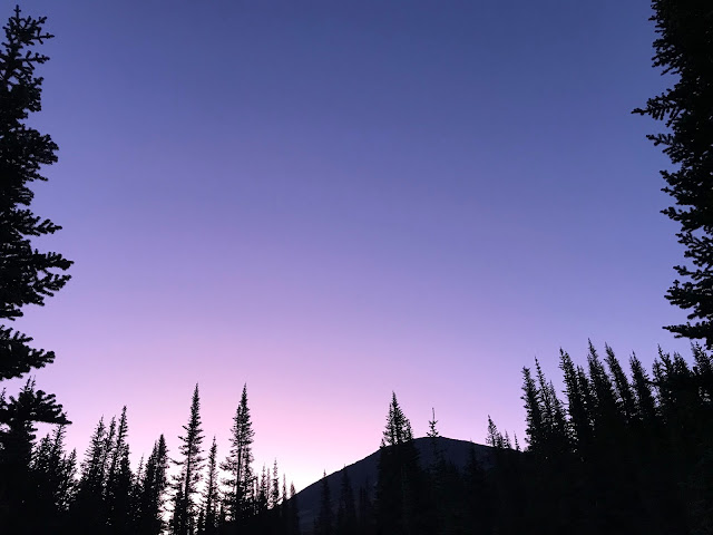 Tekarra mountain, with the sunrise glow hitting it's peaks.


More Sound of Music-esque views!


Once we had sunk lower than the tree line, I started getting bored from the lack of a view. The last 8 km after reaching the Signal Campsite felt like forever; the downhill, gravel, access road in the trees seemingly stretched on for hours. My boredom lent itself to absentmindedness and soon I was spraining my ankles multiple times :/ Luckily, none of them were too bad. We passed group of bikers and only after a long time saw another human, a single woman hiker walking towards us. I asked her how far ahead the trailhead parking lot was and was happily surprised when she answered, "oh, it's right around the corner!"

Despite not being able to enjoy campfires at night, Skyline Trail was a great hike to do; our efforts were rewarded well by the views. Now onto my next adventure!


Comments
Post a Comment